WELCOME TO RIVER DAVES PLACE

Powell trip planned 7/29-8/3

WTR&PWR

Well-Known Member
Joined
Mar 14, 2021
Messages
1,024
Reaction score
1,698
Been boating in the river for almost my whole life but have never made it to Powell. Does anyone have a good guide? With dangling rope closed I’m wondering how far we can explore. We have 3 boats going with relatively similar capacity for fuel. Only one of us has been to Powell. We are staying in Page and have reserved slips at antelope marina. It’s always been a bucket list item and with the snowmelt this year I feel like it may be our best opportunity to see it as high as we can.
 

throttle

c ya on da lake
Joined
Oct 4, 2007
Messages
12,041
Reaction score
11,028
Sounds like you are on the right track for your first time. A+ on a slip at Antelope Point!

Gas is the only thing that will be problematic if you plan to go too far. But fear not, there is plenty to see within the distance you will travel in any direction.

All of the beaches we have known for last few years are now under water, its gonna be like a new place again for us this season.
 

Nanu/Nanu

Don't wait til' life's easy to be happy
Joined
Jul 30, 2020
Messages
2,720
Reaction score
4,935
I dont know your capacity for fuel i always carry 2 fivers. When i leave from wahweap and go up to last chance/rock creek area and come back im at 1/4 of a tank. Probably 15 gallons or so left.

Being that you are leaving from antelope to you wont have to deal with the worst/longest part of the maytag straights. (Side note the cut Maybe open for your trip... So the new maytag straights may be between warm creek and Padre bay) GOOD NEWS though! Thats a very short section.

So... I would venture to say if you carry extra 10/15 gallons of fuel you could wander up as far as escalante. Mile marker 62 ish. You wont have much fuel to spare so dont eff around but its absolutely stunning.

We have done it with a full boat of adults and 10 gallons leaving from warm creek in an advantage 22' citation with 496 ho. But we put 10 gallons in up in escalante before coming back.

Its an all day affair but it's worth it.

If not check out Navajo canyon, labyrinth, face canyon, last chance, west canyon, rock creek, rainbow bridge, twilight canyon, cathedral canyon.

Twilight and cathedral canyon (i believe are the names) are side canyons between rainbow bridge, and where dangling rope was. They are on opposite sides of the main channel but when you get in that area there are some neat side canyons to explore with your boat.

If you can order a map you maybe to kind of start looking and planning your day trips.

So freaking pumped for you man!

And thanks for using the new section for lake Powell man!!!
 

WTR&PWR

Well-Known Member
Joined
Mar 14, 2021
Messages
1,024
Reaction score
1,698
I dont know your capacity for fuel i always carry 2 fivers. When i leave from wahweap and go up to last chance/rock creek area and come back im at 1/4 of a tank. Probably 15 gallons or so left.

Being that you are leaving from antelope to you wont have to deal with the worst/longest part of the maytag straights. (Side note the cut Maybe open for your trip... So the new maytag straights may be between warm creek and Padre bay) GOOD NEWS though! Thats a very short section.

So... I would venture to say if you carry extra 10/15 gallons of fuel you could wander up as far as escalante. Mile marker 62 ish. You wont have much fuel to spare so dont eff around but its absolutely stunning.

We have done it with a full boat of adults and 10 gallons leaving from warm creek in an advantage 22' citation with 496 ho. But we put 10 gallons in up in escalante before coming back.

Its an all day affair but it's worth it.

If not check out Navajo canyon, labyrinth, face canyon, last chance, west canyon, rock creek, rainbow bridge, twilight canyon, cathedral canyon.

Twilight and cathedral canyon (i believe are the names) are side canyons between rainbow bridge, and where dangling rope was. They are on opposite sides of the main channel but when you get in that area there are some neat side canyons to explore with your boat.

If you can order a map you maybe to kind of start looking and planning your day trips.

So freaking pumped for you man!

And thanks for using the new section for lake Powell man!!!
I actually found the section by accident! I was about to post in the lounge and stumbled across it.

We are stoked. I have the GPS on the boat but need to do some research to see how it gets updated with water levels. I’m going out next week so I’m going to make some points on the map of the spots you mentioned so they are programmed in there.

I’m guessing we will start with some mid range spots and check how much fuel we used each day. Venture out a little more each day.

I just reached out to my buddy too I think we may have slips are wahweap and not antelope I think I was screwed up.
 

Nanu/Nanu

Don't wait til' life's easy to be happy
Joined
Jul 30, 2020
Messages
2,720
Reaction score
4,935
No sweat
We are stoked. I have the GPS on the boat but need to do some research to see how it gets updated with water levels. I’m going out next week so I’m going to make some points on the map of the spots you mentioned so they are programmed in there.


Going out next week? Like your coming to Powell? Oh wait you're going to your boat wherever its stored. 🤦🏼‍♂️

Water levels wont mater to much with updating your gps right now the water has come up enough that wahweap is safe. Basically every where else the islands in the main channel are still exposed and visible. So if you dont get the water level updated its no biggie.

When you go off in the side canyons have some eyes watching forward for you. Face is notorious for having lots of whales. Every where else just dont go faster than you can see forward. Obviously as you get close to the shore for beaching be on the watch.

3 years ago i thought i would never make it without a depth finder but here i am today still without one.
 
Last edited:

throttle

c ya on da lake
Joined
Oct 4, 2007
Messages
12,041
Reaction score
11,028
I actually found the section by accident! I was about to post in the lounge and stumbled across it.

We are stoked. I have the GPS on the boat but need to do some research to see how it gets updated with water levels. I’m going out next week so I’m going to make some points on the map of the spots you mentioned so they are programmed in there.

I’m guessing we will start with some mid range spots and check how much fuel we used each day. Venture out a little more each day.

I just reached out to my buddy too I think we may have slips are wahweap and not antelope I think I was screwed up.
If you have slips at Wahweap I might suggest starting your days a little earlier to get thru the Narrows (aka Maytag). The Narrows has a reputation of rough water, that is why it’s referenced as the “Maytag” wash machine.

Topping off for gas when passing Antelope Point would be good plan too, however expect docks to busy in the mornings.

Be a safe smart boater / boy scout. It’s a big place, help is not ever close.

You gonna have a great time!
 

DaveH

Well-Known Member
Joined
Sep 9, 2008
Messages
2,782
Reaction score
3,987
Been boating in the river for almost my whole life but have never made it to Powell. Does anyone have a good guide? With dangling rope closed I’m wondering how far we can explore. We have 3 boats going with relatively similar capacity for fuel. Only one of us has been to Powell. We are staying in Page and have reserved slips at antelope marina. It’s always been a bucket list item and with the snowmelt this year I feel like it may be our best opportunity to see it as high as we can.
the only down side to leaving the boat in the water is having to pay a premium price for fuel.......not to mention having to haul all your coolers and so forth a long way to where you park.

because launching is relatively easy at powell, i choose to just pull the boat out when i stay at page (which i rarely do anynmore). the convenienece of taking the boat with you to prepare each day and the fuel savings make it worth it. i'd even offer it will take you LESS time to just drop the boat in and go then having to haul everything to the boat.

as for range.....do whatever you can to bring as much fuel additionally with you as you reasonable/safely can because you really want to visit escalante...its the hart of lake powell. its 68 miles just to the escalnate turn off, then you can boat another 25-30 miles into escalante. so figure 200 miles round trip with no other sight seeing excursions. my hallet twin 383's holds 125 gallons...... a trip from wahwheep to escalante and back.....throw in a little other detours here and there......i can go through 80-90 gallons a day for a trip like that.
 

WTR&PWR

Well-Known Member
Joined
Mar 14, 2021
Messages
1,024
Reaction score
1,698
No sweat


Going out next week? Like your coming to Powell? Oh wait you're going to your boat wherever its stored. 🤦🏼‍♂️

Water levels wont mater to much with updating your gps right now the water has come up enough that wahweap is safe. Basically every where else the islands in the main channel are still exposed and visible. So if you dont get the water level updated its no biggie.

When you go off in the side canyons have some eyes watching forward for you. Face is notorious for having lots of whales. Every where else just dont go faster than you can see forward. Obviously as you get close to the shore for beaching be on the watch.

3 years ago i thought i would never make it without a depth finder but here i am today still without one.
My bad on the communication. I meant I will be in havasu next week and go on the boat gps there. I can zoom out like Google maps and input the points for lake Powell.
 

throttle

c ya on da lake
Joined
Oct 4, 2007
Messages
12,041
Reaction score
11,028
the only down side to leaving the boat in the water is having to pay a premium price for fuel.......not to mention having to haul all your coolers and so forth a long way to where you park.

because launching is relatively easy at powell, i choose to just pull the boat out when i stay at page (which i rarely do anynmore). the convenienece of taking the boat with you to prepare each day and the fuel savings make it worth it. i'd even offer it will take you LESS time to just drop the boat in and go then having to haul everything to the boat.

as for range.....do whatever you can to bring as much fuel additionally with you as you reasonable/safely can because you really want to visit escalante...its the hart of lake powell. its 68 miles just to the escalnate turn off, then you can boat another 25-30 miles into escalante. so figure 200 miles round trip with no other sight seeing excursions. my hallet twin 383's holds 125 gallons...... a trip from wahwheep to escalante and back.....throw in a little other detours here and there......i can go through 80-90 gallons a day for a trip like that.
Great point made!

In recent years with low lake levels and ramps being shut down I had just succumbed to the addition expense of gas at AP and used cart services to haul our coolers and day packs up and down daily. Depending on day of the week and time of day, we found this to sometimes bite us in ass with a longer than usual wait times for a cart.
 

DaveH

Well-Known Member
Joined
Sep 9, 2008
Messages
2,782
Reaction score
3,987
Great point made!

In recent years with low lake levels and ramps being shut down I had just succumbed to the addition expense of gas at AP and used cart services to haul our coolers and day packs up and down daily. Depending on day of the week and time of day, we found this to sometimes bite us in ass with a longer than usual wait times for a cart.
exactly.

i wait unitll last minute to decide if we camp or stay in Page. the reason? the weather. if it looks like it will be unseasonably hot (at night when it makes it uncomfortable to sleep) we will get a room in page or wahwheep. otherwise we camp.

since i dont have a cabin cruiser with fridge and all that, we only take enough food for two days. first day camp reasonably close to antelope so in the morning of the second day i can get ice. then run up to escalante and camp. morning of the third day, back to page, fuel and enough food for two more days. repeat.

this worked a lot better when dangling rope was open but those days are over. thanks NPS.
 

mesquito_creek

Well-Known Member
Joined
Sep 25, 2009
Messages
3,913
Reaction score
6,798
It took me years to get up to Escalante…. There is more to do on the southern end from Wahweep to the San Juan than you can do in a week IMO for a first trip. If you have 2 tanks it’s time to go back when the first one is empty! LOL
 

havasuhusker

Well-Known Member
Joined
Mar 6, 2008
Messages
1,221
Reaction score
1,426
If you're leaving your boat at Antelope, I'd suggest using the valet ramp ($50). That way you won't have to put in at Wahweep or Stateline.
 
Last edited:

J DUNN

Unknown Member
Joined
Jun 2, 2015
Messages
1,612
Reaction score
4,366
If you're in slip at Wahweap the cut will be open and will save you from half of the rough channel. Lake is averaging going up a foot a day so cut will be open in about two weeks. The only IF is mid July the lake usually starts dropping as runoff slows. No way to see for sure how the massive winter will affect that so while cut will be open in a few weeks there is potential it might be unusable again when you're there. Watch on lakepowellwaterdata.com as you get closer to see water levels.

As for your GPS, I don't think it will update based on Lake levels. I would find it nearly impossible to have all terrain and shoreline mapped at each 1 foot increment of lake level, it's just too much info. I've searched and never found that info. If you do find a way to do that please post it here as that would be very helpful to newbies.

I just spoke with @Hammer who is there now. I just got home on Saturday and will be back up there in July 20-27.

I want to research and post GPS coordinates of the cool sites to see so people can plug them in and go check them out.
 

mesquito_creek

Well-Known Member
Joined
Sep 25, 2009
Messages
3,913
Reaction score
6,798
If you're in slip at Wahweap the cut will be open and will save you from half of the rough channel. Lake is averaging going up a foot a day so cut will be open in about two weeks. The only IF is mid July the lake usually starts dropping as runoff slows. No way to see for sure how the massive winter will affect that so while cut will be open in a few weeks there is potential it might be unusable again when you're there. Watch on lakepowellwaterdata.com as you get closer to see water levels.

As for your GPS, I don't think it will update based on Lake levels. I would find it nearly impossible to have all terrain and shoreline mapped at each 1 foot increment of lake level, it's just too much info. I've searched and never found that info. If you do find a way to do that please post it here as that would be very helpful to newbies.

I just spoke with @Hammer who is there now. I just got home on Saturday and will be back up there in July 20-27.

I want to research and post GPS coordinates of the cool sites to see so people can plug them in and go check them out.
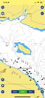
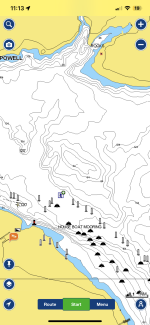
Navonics which incorporates both gps for your location and bathymetry for the underwater topography allows you to set the lake level. It works pretty good in that regard. It’s not perfect but it will give a decent approximation of the shoreline, how far back the cove goes etc…

Here is two screen shots with the lake lake set for when the island is exposed and underwater just outside the stateline ramp

I ALWAYS use navonics back in the canyons
 

Attachments

  • IMG_1032.png
    IMG_1032.png
    439.2 KB · Views: 40
  • IMG_1031.png
    IMG_1031.png
    556 KB · Views: 35

Nanu/Nanu

Don't wait til' life's easy to be happy
Joined
Jul 30, 2020
Messages
2,720
Reaction score
4,935
So it depends on your fuel capacity. This last week we camped in the back of rock creek. 36 miles up lake. @Hammer and @pull-on stopped in with their amazing hallets and they had lots of fuel left but the have big 120+ gallon gas tanks.

The two boats ive been to escalante in had 65 gallon tanks. So i Carry extra fuel going up lake.

Moral of the story in short is just pay attention to your fuel consumption. But the farther you go uplake the calmer the water gets!
 

Hammer

Well-Known Member
Joined
Apr 17, 2010
Messages
22,354
Reaction score
14,274
@pull-on and I just got back. From Wahweap through the narrows I could get to West Canyon and Back on Roughly 60 gallons. navionics worked great for us. After we left @Nanu/Nanu we made it all the way up to reflection canyon before heading back 120 miles total miles and I think I had a 3/8 to a 1/2 tank(175 gallon tank/twin merc 525's, I went 40 miles the day before) when I got back.

I want to make a run from Antelope/Wahweap to Bullfrog next time im there in one shot. I felt like I got blue balls when we had to turn around and head back to Wahweap from Reflection. There wasn't a boat in sight past Rock Creek, I wish I could have kept going past reflection...
IMG_1932.png
IMG_1931.png

A couple screenshots. Unless you zoom in on our route it’s really hard to put in perspective how far we went. I’d live to log more data next time with fuel consumption and miles gone next time. We we’re winging it every day and I think with more planning we could have seen more.

Already looking forward to the next trip!
 

mesquito_creek

Well-Known Member
Joined
Sep 25, 2009
Messages
3,913
Reaction score
6,798
@pull-on and I just got back. From Wahweap through the narrows I could get to West Canyon and Back on Roughly 60 gallons. navionics worked great for us. After we left @Nanu/Nanu we made it all the way up to reflection canyon before heading back 120 miles total miles and I think I had a 3/8 to a 1/2 tank(175 gallon tank/twin merc 525's, I went 40 miles the day before) when I got back.

I want to make a run from Antelope/Wahweap to Bullfrog next time im there in one shot. I felt like I got blue balls when we had to turn around and head back to Wahweap from Reflection. There wasn't a boat in sight past Rock Creek, I wish I could have kept going past reflection... View attachment 1244018 View attachment 1244019
A couple screenshots. Unless you zoom in on our route it’s really hard to put in perspective how far we went. I’d live to log more data next time with fuel consumption and miles gone next time. We we’re winging it every day and I think with more planning we could have seen more.

Already looking forward to the next trip!

Reflection used to have some great camp spots and always full of houseboats… sounds like you could have the whole place to yourself if you have the range
 

Hammer

Well-Known Member
Joined
Apr 17, 2010
Messages
22,354
Reaction score
14,274
Reflection used to have some great camp spots and always full of houseboats… sounds like you could have the whole place to yourself if you have the range
There was several houseboats in reflection, I was actually pretty surprised they could fit back there...
 

J DUNN

Unknown Member
Joined
Jun 2, 2015
Messages
1,612
Reaction score
4,366
@pull-on and I just got back. From Wahweap through the narrows I could get to West Canyon and Back on Roughly 60 gallons. navionics worked great for us. After we left @Nanu/Nanu we made it all the way up to reflection canyon before heading back 120 miles total miles and I think I had a 3/8 to a 1/2 tank(175 gallon tank/twin merc 525's, I went 40 miles the day before) when I got back.

I want to make a run from Antelope/Wahweap to Bullfrog next time im there in one shot. I felt like I got blue balls when we had to turn around and head back to Wahweap from Reflection. There wasn't a boat in sight past Rock Creek, I wish I could have kept going past reflection... View attachment 1244018 View attachment 1244019
A couple screenshots. Unless you zoom in on our route it’s really hard to put in perspective how far we went. I’d live to log more data next time with fuel consumption and miles gone next time. We we’re winging it every day and I think with more planning we could have seen more.

Already looking forward to the next trip!


Every year in Sept. my wife and I do an adults only weekend. Sometimes friends come with us or occasionally it's just us. On one of the days we leave early and go ALL the way up to Bullfrog from Wahweap. I keep the Cobalt pinned and go 47mph the whole way there and back. 80 gallon tank, we fill up when we get there. We usually explore a new canyon up there each year and we'll drop anchor and have lunch. It's a fun way to explore the lake little by little.
 

Hammer

Well-Known Member
Joined
Apr 17, 2010
Messages
22,354
Reaction score
14,274
Every year in Sept. my wife and I do an adults only weekend. Sometimes friends come with us or occasionally it's just us. On one of the days we leave early and go ALL the way up to Bullfrog from Wahweap. I keep the Cobalt pinned and go 47mph the whole way there and back. 80 gallon tank, we fill up when we get there. We usually explore a new canyon up there each year and we'll drop anchor and have lunch. It's a fun way to explore the lake little by little.

I'd definitely have to leave the kids home for something like that.
 

McKay

Well-Known Member
Joined
Jan 22, 2015
Messages
1,391
Reaction score
1,333
the only down side to leaving the boat in the water is having to pay a premium price for fuel.......not to mention having to haul all your coolers and so forth a long way to where you park.

because launching is relatively easy at powell, i choose to just pull the boat out when i stay at page (which i rarely do anynmore). the convenienece of taking the boat with you to prepare each day and the fuel savings make it worth it. i'd even offer it will take you LESS time to just drop the boat in and go then having to haul everything to the boat.

as for range.....do whatever you can to bring as much fuel additionally with you as you reasonable/safely can because you really want to visit escalante...its the hart of lake powell. its 68 miles just to the escalnate turn off, then you can boat another 25-30 miles into escalante. so figure 200 miles round trip with no other sight seeing excursions. my hallet twin 383's holds 125 gallons...... a trip from wahwheep to escalante and back.....throw in a little other detours here and there......i can go through 80-90 gallons a day for a trip like that.
You’re the exact opposite of me. I won’t go if I don’t have a slip.
 

WTR&PWR

Well-Known Member
Joined
Mar 14, 2021
Messages
1,024
Reaction score
1,698
Trip is coming up. I have to go to havasu to grab the boat on the way. My buddy says the drive on the 40 and through flagstaff to page is a little rough. He said it’s a lot of hills. I have a dually (purposely not saying make so it doesn’t become a ford vs Chevy vs ram debate haha) so I have a solid tow vehicle. The boat is bigger and a lot of tongue weight. How’s the drive? Anything I should know?
 

Hammer

Well-Known Member
Joined
Apr 17, 2010
Messages
22,354
Reaction score
14,274
Trip is coming up. I have to go to havasu to grab the boat on the way. My buddy says the drive on the 40 and through flagstaff to page is a little rough. He said it’s a lot of hills. I have a dually (purposely not saying make so it doesn’t become a ford vs Chevy vs ram debate haha) so I have a solid tow vehicle. The boat is bigger and a lot of tongue weight. How’s the drive? Anything I should know?
Head out to Kingman and bypass the 40 between Kingman and seligman . Take Route 66 out of Kingman and it’ll drop you off at the 40/seligman and you can hop back on the 40 and head to Powell. Was a nice easy two lane highway.

The 40 is hammered with potholes east of Kingman
IMG_2116.png
IMG_2116.png
 

Nanu/Nanu

Don't wait til' life's easy to be happy
Joined
Jul 30, 2020
Messages
2,720
Reaction score
4,935
Then when you get to the Reservation the 89 highway between Cameron and the Gap is garbage.

Its really jumpy and we call it the Navajo rapids. I personally average 55mph in that stretch. Others may go faster but i have seen daylight under my tires going faster than that so i take it easy.

The highway 89 from the gap up to page is good and smooth sailing and you get a cool overlook.

If you turn at the gap that highway is good to rumor has it thats its 11 miles shorter. I dont take this route but ive heard from many people its good too.
 

Gramps

Older Member
Joined
Sep 24, 2007
Messages
8,828
Reaction score
12,089
Just a reminder .......... the #1 rule at Powell is watching for fast color change in the water. Whales come up FAST!!!!!!
 

Andy B.

Well-Known Member
Joined
Jul 19, 2011
Messages
5,899
Reaction score
8,477
Trip is coming up. I have to go to havasu to grab the boat on the way. My buddy says the drive on the 40 and through flagstaff to page is a little rough. He said it’s a lot of hills. I have a dually (purposely not saying make so it doesn’t become a ford vs Chevy vs ram debate haha) so I have a solid tow vehicle. The boat is bigger and a lot of tongue weight. How’s the drive? Anything I should know?
A little rough isn't the word it's horrible! I drive from Vegas to Ash Fork every other week knocks truck out of CC !! I spend a lot of time in the left lane until I see a car coming up.
 

Nanu/Nanu

Don't wait til' life's easy to be happy
Joined
Jul 30, 2020
Messages
2,720
Reaction score
4,935
Happy to see you're trip is going well! How far up lake have you made it?
 
Top