Hello all,
Over the past 6 months, I've become an everyday lurker here on RDP, and I'll post every now and again. Finally bought a boat for my young family this past summer. I have the wifey, and two boys (9&11). We came to Havasu twice last summer. Once in July to buy the boat, and then back again in late Sept. We picked up a 1987 26' Caribbean daycruiser. Really enjoying it a lot.
Fast forward to now... I see lot of threads on here about Parker, the 'River', La Paz, Pirates, Topac, Havasu Springs, etc. Even today a post about possible legislation around the Topac area. I went to Sandbar once about 10 years ago on a random trip to Havasu for a buddy's bachelor party. And I was lucky enough to take part once in the debauchery that was Copper Canyon in the early 90's during a Spring Break trip in college. But that's the extent of my knowledge of the area.
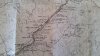
You guys post pics up here all the time of areas outside of Havasu and it's so beautiful, but I have no idea how to get there or where it is in relation to Havasu. Long story long, I'm just wondering if somebody has an image or webpage that lays this all out. Thanks so much guys and gals!
Over the past 6 months, I've become an everyday lurker here on RDP, and I'll post every now and again. Finally bought a boat for my young family this past summer. I have the wifey, and two boys (9&11). We came to Havasu twice last summer. Once in July to buy the boat, and then back again in late Sept. We picked up a 1987 26' Caribbean daycruiser. Really enjoying it a lot.
Fast forward to now... I see lot of threads on here about Parker, the 'River', La Paz, Pirates, Topac, Havasu Springs, etc. Even today a post about possible legislation around the Topac area. I went to Sandbar once about 10 years ago on a random trip to Havasu for a buddy's bachelor party. And I was lucky enough to take part once in the debauchery that was Copper Canyon in the early 90's during a Spring Break trip in college. But that's the extent of my knowledge of the area.
You guys post pics up here all the time of areas outside of Havasu and it's so beautiful, but I have no idea how to get there or where it is in relation to Havasu. Long story long, I'm just wondering if somebody has an image or webpage that lays this all out. Thanks so much guys and gals!